Sunday, November 8, 2015

Whitewater Valley

The forecast was for two days of sun with temperatures in the 70s. For the first week of November, this was reason to jump in the truck for an impromptu trip- probably the last for the season. The fall leaves were in their final fading glory around the homestead and we had hopes of extending the fall color season a bit by heading south.

(You may click on photos for a larger version).

Serviceberry in our front yard.
Fall is over when more leaves are on the ground than on trees.

After completing some errands on Tuesday morning, we packed up the camper and followed the Mississippi River south, stopping for lunch at Frontenac State Park. The park was largely deserted on this beautiful fall day. One of the perks of retirement is traveling during the week when most people are hard at work.

PB&J for lunch.
A view of the Mississippi from our lunch spot.

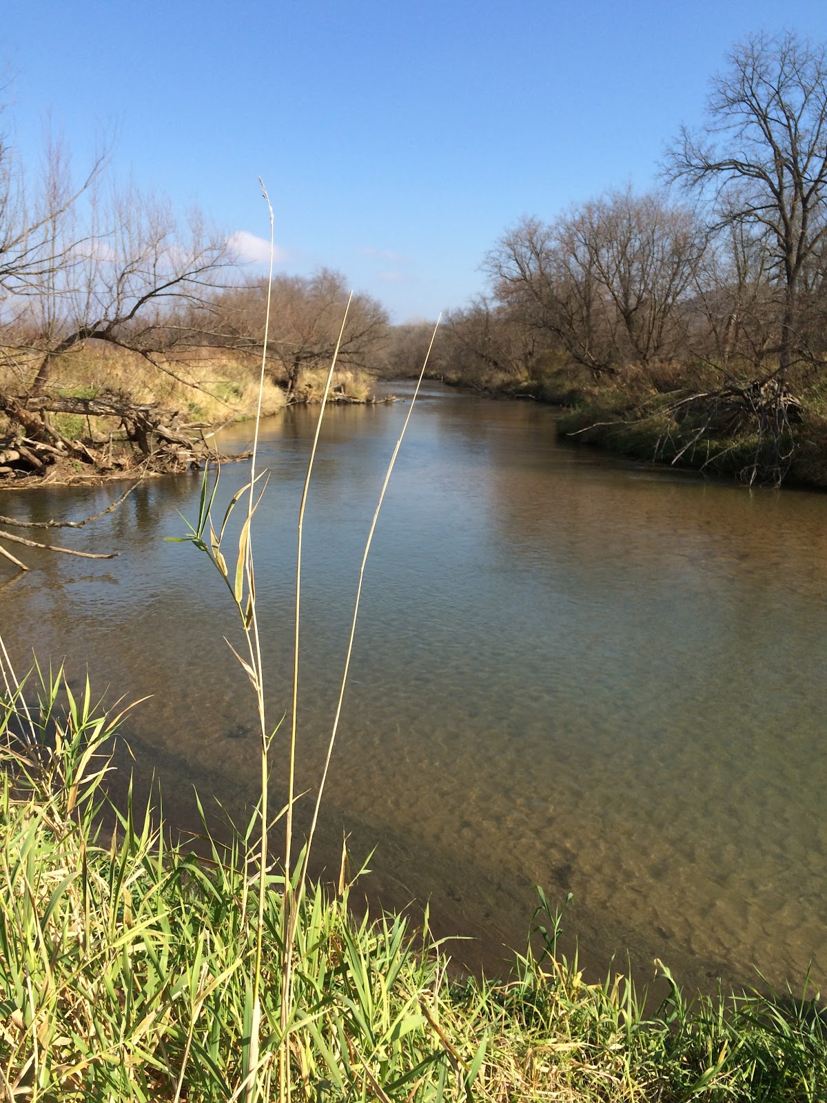
We had selected the Whitewater River Valley as our destination. The Whitewater River Valley runs through the driftless area of southeastern Minnesota toward the Mississippi River- the same landscape as across the Mississippi in Wisconsin, the scene of several recent trips. It is a landscape of limestone bluffs, cold water streams and hardwood forests.


The valley is an object lesson in land use practices and conservation. Native people had lived for thousands of years in the valley carved by glacial runoff. They named the river for the color it turned as high water in the spring eroded the light clay banks.

"When settlers arrived, they found a great diversity of plant life in the Blufflands Landscape Region. In the valleys, they discovered a rich, bottomland forest with clean, spring-fed streams teeming with native brook trout. Oaks grew on some slopes with maple and basswood trees on other slopes. South facing hillsides were covered with prairie. Much of the uplands contained oak savanna, gently rolling prairie with scattered oaks." -MN DNR
Following a treaty with the Dakota people in 1851, European settlers began to arrive and quickly set about clearing land for grazing and farming. Small towns quickly sprang up along the river- Beaver, Whitewater Falls, Elba. Farmers cleared forested hillsides and extended their fields and pastures up the steep slopes. Heavy rains, which in earlier times had been soaked up by the forests, now washed soil from the slopes and into the river. By the early 1900s, flooding became a major problem. The exposed sandstone eroded and covered the land with sand (more info and pictures here). Eventually by the 1930s, repeated flooding had devastated the area and many farms and towns were abandoned. You can read about one such town here. In less than a hundred years, an idyllic valley thousands of years in the making was decimated.

Beginning in the 1940s, conservation practices were put in place to stop erosion. The 28,000 acre Whitewater Wildlife Management area was established and erosion-prone land was purchased by the state. Today the Whitewater Watershed Project works to promote good land use practices. As a result, the valley is again beautiful and productive. The Whitewater River is a designated trout stream. But the challenge continues to keep it that way.

Whitewater Valley

We reached the valley in the afternoon and discovered to our surprise and disappointment that recent strong winds and rain had stripped the fall leaves from the trees. The landscape was ready for winter- the dominant colors were greys and browns. Our hoped for fall color was nowhere to be seen and far less than at home. But no matter, the weather was beautiful and we would enjoy ourselves.

We checked in at Whitewater State Park. We selected a site in the so-called primitive lower campground, which we had all to ourselves. Our site was alongside the Whitewater River, and the sound of the river provided a nice background song for our camp. With the end of daylight savings time, the sun sets early- around 5 PM. We made dinner and ate in the dark. After dinner chores, we took Rocky for a walk and enjoyed the stars. We finished the evening with a nice campfire.


Our campsite at Whitewater State Park.


The campground was not busy.

Morning promised a beautiful warm fall day. We ate breakfast and planned to explore the valley. We had seen an intriguing landmark on the map and decided to make the 1.5 mile hike in to see it. The trail followed the route of an old stage coach road through the woods. I unfortunately forgot the phone in the truck so I took no pictures. We did not know what we would find at the end but it was a nice day for a walk in the woods. After a final bend in the trail, we arrived at the Marnach House. Hidden from view until the very end, it was a pleasant surprise. The house is listed on the National Register of Historic Places and has an interesting story. You can read more here.


Marnach House (photo from the internet here)

We spent some time sitting in the sun at the house before heading back to the truck. Our next hike was to try to find an old cemetery from the 1850s marked on the map. There were two trails marked on the map that were longer than we wanted to do. We selected another route that looked shorter but would require crossing the river. We gambled that we would find a way across. When we reached the river, we scouted for a crossing. There was a downed tree that could be a bridge. I found a tree branch that could work as a walking stick and tested out walking on the tree. It was solid. About 2/3 way across, the surprisingly strong current of the river had cut a channel under the tree that was too deep for my stick support. Not being willing to try to advance on the narrow tree without support, I carefully turned around. We ultimately opted not to risk a dunk in the cold water. We were stopped by the river but had an enjoyable walk anyway.

A last bit of fall color.
 

The Whitewater River.


A nice walk.


Panorama of the valley floor.


We decided to visit another nearby state park to have a picnic lunch. Carley State Park was donated to the state in 1948 by state senator James Carley in hopes of preserving an impressive stand of native white pines. It is a small park with some rustic camping (closed for the season) and a nice picnic ground along the river. We had a nice lunch, again having a park all to ourselves but for some deer taking refuge from the fall hunt. We realized later that we took no pictures.


After lunch we returned to Whitewater State Park, enjoying the drive through the agricultural landscape surrounding the valley. We stopped at the visitor center and registered for another night in the campground. While there we toured a small but nicely done exhibit with a wealth of information on the Whitewater Valley.


With our campsite secured and the afternoon sun still warm, we opted for another hike to nearby Chimney Rock. The trail took us steeply up a limestone cliff to a nice overlook. The namesake Chimney Rock was bathed in late afternoon sun. We took a different route down with a long, winding, wooden staircase making the descent easy. The soft sandstone at the bottom was evidently too much to pass up by modern-day petroglyph/graffiti makers.


Chimney Rock

Setting sun through a hole in the rock.

View of the river below.

Another view of Chimney Rock and the valley below.

Modern day petroglyphs (or vandalism, depending on your viewpoint).

Stating the obvious.

Pleasant picnic grounds built by the CCC.

Chilling in the parking lot after the hike up to Chimney Rock.

Back at camp we made an early dinner while daylight waned. Another campfire held the darkness at bay until, pleasantly tired from all the days walking, we retired to our snug bed. The weather report promised rain and colder temps for the coming day and we would return home with one stop on the way.


The last of the season's tomatoes went in dinner.


Camp cooking.

As promised, the day dawned cloudy and threatening rain. We packed up and headed for our next stop in Wabasha, Minnesota. We enjoyed a tour through the valley back to the Mississippi River and our trip north.

Panorama of the Whitewater marshes.

Another view of the marshes.


Wabasha, Minnesota is the site of the National Eagle Center, our planned stop. We arrived in time to have a nice breakfast at Stacey's Kitchen before heading over to the Eagle Center. The Center is located on the banks of the Mississippi River in downtown Wabasha. Wabasha is a favorite wintering site for eagles. The current from the confluence of two rivers, the Mississippi and the Chippewa River from Wisconsin, keeps the water open all winter, providing a food source for the eagles. When we arrived, the resident eagles were enjoying their outdoor weathering perches adjacent to the building and overlooking the riverwalk trail that passes by the building.

The Center is filled with interesting exhibits about eagles, eagle art and beautiful wall murals, one of which was being painted by the artist while we were there. There are live, captive eagles in residence, found injured in the wild and rehabilitated by the Raptor Center at the University of Minnesota. These birds have injuries that preclude them from being released back to the wild, so they live on at the center as ambassadors for their species. During our visit there were three bald eagles and one golden eagle present.

The live eagle display area includes generous windows to the outside overlooking the river. While we were there, a wild eagle flew past the window, sending the resident eagles into a frenzy of vocalizing, flapping their wings and hopping up and down. The naturalists explained the behavior as territorial displays, expressing their displeasure at the incursion of another eagle into their space. Cool to see.

Our visit included a talk about eagles by one of the staff experts, including a visit from one of the eagles. They are majestic birds and we enjoyed our visit very much. After a couple of hours at the Center, we headed for home, another trip completed. With winter on the way, it will be some months before we head out in the camper again.


National Eagle Center.


Eagle ambassador.
An interesting presentation.


Thursday, October 22, 2015

Fall Colors and Conservation Giants

Rural panorama (please click on photos for a larger version)
Earlier in the summer we had made a trip to Taliesen through the driftless area of Wisconsin (trip report here). At the time, I resolved to return to the area in the fall, imagining it to be beautiful in fall color. I also wanted to visit a couple of sites celebrating two giants in the land conservation movement that we had not had time to visit on our last trip. October arrived and with it Kathy's annual trip to St. George, Utah for the Huntsman Senior Games volleyball tournament. Rocky and I decided to take a road trip.

I left early on a Tuesday morning to beat the rush hour and headed for the Mississippi River valley. The weather was cloudy, cold and threatening rain. Not the best for photos or sightseeing. Last trip we followed the river on the Wisconsin side. This trip I stayed on the Minnesota side, crossing the river at LeCrescent. Once past LaCrosse, I chose the back roads, hoping to see some pleasant scenery. The driftless area is full of small, picturesque farms surrounded by limestone bluffs and hardwood forests. Small cold water streams flow from the limestone toward the Mississippi. Twisty, small roads follow the terrain, connecting small towns and make for an interesting drive.

Mississippi River Bluffs.

Wisconsin back roads.

My destination this day was Mirror Lake State Park. I arrived in time for a short walk around the park before dinner. The clouds were breaking up, allowing moments of late afternoon sun. I had planned to put a kayak in the park's namesake lake but the weather was a bit too chilly and damp for me in the waning day. I settled for a walk in the woods.

Mirror Lake.
Mirror Lake woods.

I picked a nice spot to camp in the mostly empty campground and made dinner.

Mirror Lake camp at sunset.

I had noticed the TPMS warning light as I backed into the campsite but didn't think much of it as I had recently reset the pressures and figured one of the tires needed some more air. After dinner as I was putting things away in the truck, I noticed the passenger side rear was flat! It was already getting dark. I decided to tackle the tire change in spite of the dark as I didn't want to be delayed getting going in the morning. This would be interesting because I hadn't ever changed a tire on this truck. I had always meant to do a practice run at home in the driveway to make sure everything worked but had never got around to it. My owner's manual had been taken in a summer burglary of the truck so I had no guidance. I used my phone to consult the all-knowing internet. The hardest part was getting the spare out from under the truck. In the dark I couldn't see the mechanism and had to figure it out by touch. I had bought a heavy-duty hydraulic jack when we got the camper but hadn't used it yet. Long story short, I got the tire changed without too much trouble. The issue was quite apparent- a very large torx-head screw was nicely lodged in the center of the tread. Not having a plug set with me, I decided to travel the rest of my trip without a spare rather than lose half a day getting it repaired. Risky, but we do have roadside insurance and it worked out ok.

Culprit

Brand new spare mounted in place.


The next morning after a breakfast of oatmeal and a hot cup of chai tea, I was off to visit the Aldo Leopold Foundation and pay my respects to Aldo Leopold's shack on the Wisconsin River.

From the Foundation website:
Considered by many as the father of wildlife management and of the United States’ wilderness system, Aldo Leopold was a conservationist, forester, philosopher, educator, writer, and outdoor enthusiast.
 In 1935, he and his family initiated their own ecological restoration experiment on a worn-out farm along the Wisconsin River outside of Baraboo, Wisconsin. Planting thousands of pine trees, restoring prairies, and documenting the ensuing changes in the flora and fauna further informed and inspired Leopold.
A prolific writer, authoring articles for professional journals and popular magazines, Leopold conceived of a book geared for general audiences examining humanity’s relationship to the natural world. 

A little more than a year after his death Leopold’s collection of essays A Sand County Almanac was published. With over two million copies sold, it is one of the most respected books about the environment ever published, and Leopold has come to be regarded by many as the most influential conservation thinker of the twentieth century.
A Sand County Almanac was instrumental and affirming in my mid-life career choice of land conservation and a visit to the shack is a time-honored pilgrimage for any person concerned with ecology, land conservation and living in harmony with the natural world.

 “We abuse land because we regard it as a commodity belonging to us. When we see land as a community to which we belong, we may begin to use it with love and respect.
“A thing is right when it tends to preserve the integrity, stability, and beauty of the biotic community. It is wrong when it tends otherwise.”
 “The last word in ignorance is the man who says of an animal or plant, “What good is it?” If the land mechanism as a whole is good, then every part is good, whether we understand it or not. If the biota, in the course of aeons, has built something we like but do not understand, then who but a fool would discard seemingly useless parts? To keep every cog and wheel is the first precaution of intelligent tinkering.”
-Aldo Leopold

The Foundation is located in a beautiful, environmentally advanced building on the site where Aldo Leopold died fighting a fire on a neighbor's property. There is an exhibit covering Leopold's life and information on his children who created the Foundation. The land where the shack is located is a couple of miles down the road. The shack is not open to the public except by tour. Tours are held on Saturday afternoons. I decided I didn't want to share my visit with a crowd of people in order to see inside. On Wednesday I was mostly by myself.

I spent some time in the exhibit, learning about the 5 Leopold siblings, all esteemed scientists in their own right, enjoyed seeing artifacts from Leopold's life and then drove to visit the shack.

Levee Road- to the shack.

Aldo Leopold Foundation

The entrance. The building has the highest LEED certification.

The farm with the shack (a former chicken coop) was the second home and experimental laboratory for the Leopold family. They planted over 30,000 seedlings and documented the natural processes of the land and river. While the site is not pristine, or even "correct" in terms of the original vegetation that would have existed absent the hand of man, it's transformation from the ruined, barren farm is a lovely testament to Leopold's philosophy.
 "On this sand farm in Wisconsin, first worn out and then abandoned by our bigger-and-better society, we try to rebuild, with shovel and axe, what we are losing elsewhere. It is here that we seek- and still find- our meat from God." -Aldo Leopold

Walking path to the shack.
The pines were all planted by the Leopold family.

First glimpse of the shack.
The shack in all its glory.

Discovered on a walk in the woods.

The "Parthenon."

Sand blowout persisting since the 30s.

The Wisconsin River adjoining the shack property.

River floodplain.
Another view of the shack.

Sitting on Aldo's bench.

The iconic bench.

Another view.


 ~~~
"In every walk with nature one receives far more than he seeks."
 “Climb the mountains and get their good tidings. Nature's peace will flow into you as sunshine flows into trees. The winds will blow their own freshness into you, and the storms their energy, while cares will drop away from you like the leaves of Autumn.”
"When one tugs at a single thing in nature, he finds it attached to the rest of the world."

"Keep close to Nature's heart... and break clear away, once in awhile, and climb a mountain or spend a week in the woods. Wash your spirit clean."
-John Muir

 My next stop was a small county park established on the site of John Muir's boyhood home. John Muir is another giant of the land conservation movement. Called by some as the patron saint of wilderness, his writings helped save Yosemite among other great natural places. He was a founder of the Sierra Club in 1892. Born in Scotland, his family moved to Wisconsin in 1849, settling on 80 acres adjoining a small lake. Muir attended the University of Wisconsin at Madison and became known for ingenious clocks and inventions carved from wood. Some are still on display in the student union there.

Muir eventually landed in California and traveled the West, becoming passionate about saving the wilderness. John Muir attributed his interest in the environment to his time growing up on the farm. The Fountain Lake Farm, as it has come to be known is a National Historic Landmark. The second farmhouse built by the family, known as Hickory Hill, still stands and is in private ownership not open to the public. I visited the John Muir Memorial County Park and enjoyed a nice walk with Rocky, imagining Muir as a young man spending time in the same place.

Memorial to John Muir.

Sign erected by the Sierra Club.

An informative display at the trail head.


Panorama of Fountain Lake Farm.


Fountain Lake, now called Ennis Lake.
Fall color.

Rocky enjoying the walk with me.
The view from the side of the homestead.

Another view of the lake.

After spending a nice afternoon at the park and having some lunch, I drove to my next camp at Devil's Lake State Park. Devil's Lake State Park is the largest and most visited state park in Wisconsin. Established in 1911, the park surrounds a 350 acre lake which sits in a 1.7 billion-year-old gorge carved through purple quartzite by an ancient river. Tall cliffs and vast talus slopes border the lake on three sides. Two glacial moraines deposited 15,000 years ago plug each end of the gorge, making the lake. The park also includes several ancient effigy earth mounds dating from 800-1100 AD. The park offers spectacular hikes up and atop the cliffs, as well as through the interesting landscapes surrounding the gorge.

I spent two nights here and enjoyed some challenging and beautiful hikes and pleasant evenings by the campfire.

Camp at Devil's Lake State Park.

Evening campfire: where there's fire, there's smoke.

Back roads around Devil's Lake.
Another road...

And another road.

Hiking up the talus slope.
Rocky surveys the scene.

View from on top- we started at the beach below.

Trail scene.
Balanced rock.

The long view.
Another overlook.

Rocky poses at Devil's Doorway.
Beautiful quartzite.

Another overlook.

Colorful fall foliage.

Narrow path through the quartzite.
Steps up through a crack in the rock.

Long view to Devil's Lake.

Colorful leaf on a log.

Looking up at the Talus slope.

Plaque at one of the effigy mounds in the park.

Earlier plaque at the same mound.

I visited another interesting site near Devil's Lake- Parfrey's Glen. Eroded by water flows through ancient sandstone, the glen is the first natural area designated in the state of Wisconsin (1952) and a fascinating place. Embedded in the sandstone layers are pebbles of quartzite making an unusual geological layer cake. The glen was stripped by a massive flash flood in 2008, washing away all the improvements made over the years, including a boardwalk, and carving a new channel for the stream that still flows there. My walk was quiet and serene, accompanied by the sound of the wind in the trees and a blizzard of falling leaves.

Beautiful fall woods scene.
Creek flowing through Parfrey's Glen.

Parfrey's Glen.

Rock layer cake.
Quartzite pebbles encased in sandstone covered by limestone from ancient sea.

More interesting rock.

Serene stream view.

On Friday, the weekend crowds started to build in the park and I headed for home. I retraced my path to some extent and found new back roads to follow. Having the GPS-linked computer with detailed maps helped me find some scenic routes without getting lost. I enjoyed the pastoral landscapes and discovered some interesting sites.


Fall farm scene.


Another fall scene.

Young buck makes a break for it.

Fall color along the back roads.

Fall scene with old farm building.

More beauty on the back roads.

Fall "color" unexpected on this back road.

Overlook from Wildcat State Park.

Wildcat panorama.

Nice to have GPS when exploring.

I came across this conservancy traveling the back roads. This particular site is called the Tunnelville Cliffs State Natural Area- 2278 acres along the Kickapoo river. It is great to see this private conservation work going on in rural places like this.

Tunnelville Cliffs Preserve

A view of the Tunnelville Cliffs preserve.


I had planned to camp one more night at Great River Bluffs State Park in Minnesota, overslooking the MIssissippi River. Unfortunately the campground was already full by the time I got there. Since I was only a couple hours away, I decided to head home. I got home after dark, having enjoyed a fine fall color trip and feeling inspired by the examples of leadership, stewardship and forward thinking I had seen.